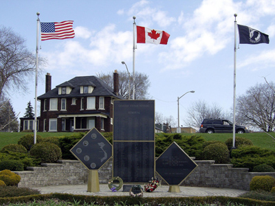
Windsor, Ontario
Base of Morpeth St.
GPS coordinates: 44.49491,-81.37826
Take a photo of your rally flag and motorcycle with the above image.*
The wreck of the HMS General Hunter lies under the sand, behind a stone breakwall just 75 metres along a concrete boardwalk from the bottom of Morpeth Street. You will see a plaque there dedicated to the wreck that provides a nice description of the wreck site.
The General Hunter was built in Amhersburg in 1806 and fought in numerous battles in the War of 1812. She was captured by the Americans in the famous Battle of Lake Erie in Sept of 1813. She then was used by the Americans in battle. After the war she was turned into a lowly transport barge named the Hunter, and driven onto this beach during a storm in 1816. All aboard survived.
The wreck was fully uncovered and identified in 2004 and all of the artifacts were removed. Most are on display in the nearby Bruce County Museum along with the captured British flag that was flying on the day of her capture. The wooden hull was reburied in the mud where it was found to preserve it in situ. The temporary breakwater in front of the site was installed to help protect the remains of the brig. "HMS General Hunter" a remarkable, historically unique and archaeologically invaluable shipwreck.
––––––––––––––––––––––––––––––––––––––––––––
*If motorcycle, rally flag and above image can't be in the same photo, submit two photos: one with rally flag and above image, and another with rally flag and motorcycle nearby. If the site is CLOSED or inaccessible, submit a photo with rally flag ad motorcycle nearby, along with an explanation.
Tour of Honor-Ontario, Canada is sponsored by Adrian Musters.
|


